Prehistoric
A Neolithic ritual landscape revealed
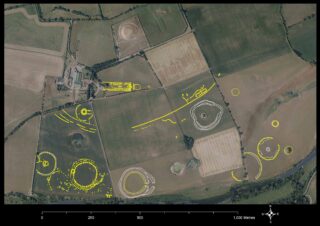
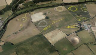
A summary of the principal sites that were identified on the Newgrange floodplain during the drought conditions in summer 2018.
Introduction
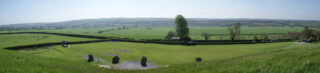
Looking south from the ridge at Newgrange Passage Tomb one can see the structure of the floodplain below, with its alluvial terraces forming steps leading down to the River Boyne, which here forms a large U-shaped bend defining the area we know today as Brú na Bóinne.
During the excavations at Newgrange between 1962 and 1975 Professor M.J. O’Kelly and Claire O’Kelly inspected sites and locations across the floodplain. Their map of the ‘Boyne Valley passage grave cemetery’ indicated a number of sites, including mounds, henges and standing stones, within the townland of Newgrange.
Today some of the sites that survive above ground level are more obvious than others. Two large mounds, Site A and Site B, impressive in their own right, are considered likely to cover passage tombs. Site A was known to be enclosed by an earthen bank. Close to the river is Site P, a large henge which was classified as an earthen embanked enclosure by Professor Seán P. Ó Ríordáin when it was first identified from the air by the Irish Army Air Corps in the 1950s.
Our knowledge of the monuments on the floodplain has been further enhanced by geophysical and LiDAR surveys conducted by Dr Steven Davis and Kevin Barton, Joe Fenwick and Joanna Leigh, which led to the identification of low-relief enclosures and subsurface evidence for other large enclosures and structures.
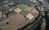
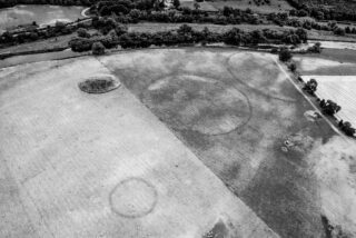
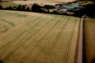
Our understanding of the extent and nature of the ritual landscape at Newgrange was to change significantly in July 2018, when aerial archaeological reconnaissance was carried out over the floodplain and across the Brú na Bóinne World Heritage Site. The near-drought conditions across the country produced differential crop growth, highlighting the existence of previously unknown sites and adding significant information about sites that were already in the archaeological record.
The National Monuments Service reconnaissance was prompted by the discovery in July of a large, complex henge monument manifesting itself as a series of cropmarks in a wheat field just south of Newgrange Farm. This spectacular discovery was made by Anthony Murphy and Ken Williams using drone technology, and its unique pattern attracted the attention of the public and media across the world.
The results of the aerial survey are still being assessed, but even at this stage there is ample evidence that the floodplain lay at the centre of a major cult centre in the Neolithic, with an array of monuments indicating funerary and ceremonial practices associated with the Great Passage Tomb and the ridge on which it is located. One of the unusual phenomena highlighted by the aerial evidence is a preponderance of pits and timber structures evidenced by post-holes, revealing sites and enclosures with a high degree of detail.
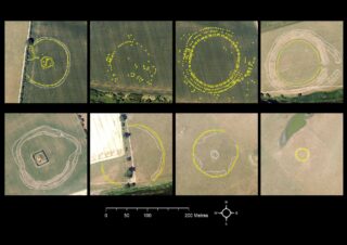
Described below is a selection of the principal sites that we have identified, interpreted and mapped. These include features that were previously unknown in the Irish archaeological record and display a sophisticated layout and design.
Henges
The predominant site type on the floodplain is the henge. ‘Henge’, a word derived from Stonehenge, is the name applied to large, circular enclosures considered to have been used for gatherings and ceremonies in the later part of the Neolithic period (c. 3000–2500 BC). The results of the NMS aerial survey and new identifications indicate that there are eight henges forming two distinct complexes, one located to the west close to the north bank of the river and the other to the east on the lowest alluvial terrace. In terms of studies of the Neolithic, any one of these sites would be important in its own right. Together they pose intriguing questions in terms of understanding the nature of such sites and their design and layout in relation to each other.
The western henge complex
On the west of the floodplain a distinct group is formed by Site P, the Geometric Henge, the Univallate Henge and a potential fourth site that we have named the Hidden Henge. The alignment of three of these henges in a south-easterly direction appears to be related to the southern edge of a large palaeochannel that traverses the Newgrange floodplain.
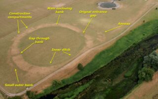
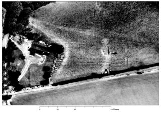
Site P
Site P, first identified in the early 1950s, is of the earthen embanked enclosure variety. The bank of such sites appears to have been constructed from material excavated from the interior of the site, leaving a broad, dished interior. The drought conditions highlighted the ‘bare bones’ of this site, exposing clearly an inner ditch, a smaller outer bank and a projection or annexe on the south-east.
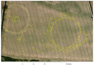
Geometric Henge
Nearby to the north-west is the site that we have called the Geometric Henge on account of the radial patterns of the layout of its enclosing elements. This henge, nicknamed ‘Dronehenge’ by Murphy and Williams, comprised three elements: an outer ring of post-holes, a middle ring of post-holes and an inner enclosure defined by double segmented ditches. All three elements appear to be concentric, suggesting contemporaneity, and are most likely the product of a single architectural concept.
Along the eastern perimeter there is an outer extension to the enclosing elements—an annexe—evidenced by a series of ditch segments arcing outwards from the perimeter of the inner circle. This annexe appears to incorporate features that are likely to form an entrance leading to the interior of the henge.
A rectangular structure can be clearly seen on the west-north-western perimeter of the double-segmented-ditched enclosure, occupying most of the space between the enclosure and the two rings of timber posts. The rectangular structure measures 22m x 16m externally (18m x 11m internally). On close inspection the cropmarks appear to reflect subsurface ditches with irregular edges, suggesting a series of large timber posts set into oblong trenches.
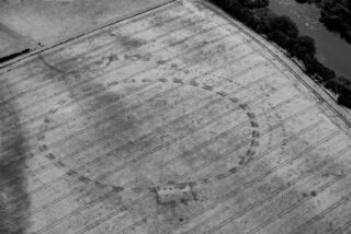
The Univallate Henge
Another henge defined by a broad bank with an internal segmented ditch became apparent. This site had been located previously by Steve Davis and Kevin Barton as a result of LiDAR imagery and geophysical survey. The aerial photographs showed the complete enclosure, c. 128m in diameter, with a central mound and an unusual configuration of timber posts at its centre. Furthermore, at the north-west perimeter an oblong enclosure can be clearly seen.
The Hidden Henge
There is also evidence of a more subtle nature for the existence of another henge between the Geometric Henge and the Univallate Henge. The enclosure of this ‘Hidden Henge’, c. 98m across, appears to be contiguous with the outer edge of the bank that forms the Univallate Henge to the north-west and would be contiguous with the outer timber circle of the Geometric Henge to the east.
This enclosure has some of the features of the Geometric Henge. At the west-north-west the circular enclosing element appears to be aligned on a rectangular feature that may be the fragmentary remains of a structure similar to that on the western perimeter of the Geometric Henge.
Site B henge complex
Site B is a large mound close to the Boyne on the east of the floodplain, on the lowest alluvial terrace. Close to the mound in grassland, three enclosures showed up clearly on the aerial photographs. These henges form a distinctive group and their design seems to contrast with the henge group on the west. Two large henge monuments, subcircular in plan and similar in appearance on the aerial photographs, can be seen.
The henge enclosures are defined by broad banks, each with an external ditch. The southern perimeter of the larger of the two henges (c. 160m in diameter) appears to run along the upper edge of the riverbank. The second henge (c. 120m in diameter) is only 12m from the perimeter of the Riverside Henge and appears to enclose a low mound at its centre.
The smallest henge in this group, c. 40m in diameter, is located close to the step of the next alluvial terrace. While it is significantly smaller than the henges on the floodplain, there is evidence that it comprises an outer bank with an internal ditch in which there are large post-holes.
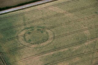
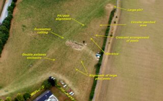
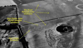
The Four-Poster Enclosure
The Four-Poster Enclosure is located close to the north-east corner of the field, immediately to the south of Newgrange Farm and c. 460m south-west of Newgrange Passage Tomb. It is sited on level ground on one of the upper alluvial terraces overlooking sloping ground, the palaeochannel and the pond to the south.
The Four-Poster Enclosure, so called after the four large post-holes located within it, manifested itself in great detail on the aerial photographs. The enclosure is defined by two rings of palisades, 5.1–5.8m apart. The inner ring defines a circular area c. 22m in diameter. The outer palisade is elliptical in plan, measuring 32m north–south and 28m east–west.
The lighter-toned cropmarks (negative cropmarks) between the two palisaded enclosures most likely indicate the presence of a bank. An entrance, c. 3.2m wide, can clearly be seen on the east-south-eastern perimeter of the enclosure, providing access through both palisades. The cropmarks indicate a structural emphasis of the entrance, with a thickening of both palisades on either side of the gap. Outside the enclosure and on the same axis as the entrance there are traces of two parallel lines of post-holes, most likely forming an ‘avenue’ leading to the enclosure.
The architectural layout of the site bears strong similarities to other such known sites that have been interpreted as Late Neolithic mortuary enclosures where excarnation rituals took place. A similar site was excavated close to the entrance of the Eastern Passage Tomb at Knowth, while another example was excavated near the Giant’s Ring at Ballynahatty, Co. Down.
The Four-Poster mortuary enclosure is located within a larger subcircular enclosure measuring 92m north–south and 95m east–west. This outer enclosure comprises a closely set double palisade most likely constructed on a bank, which shows up clearly on the aerial photographs.
Oblong Enclosure
The enclosure is defined by a ‘capsule-shaped’ ditch, with two parallel ditches forming the long axis and curvilinear ditches forming terminals at either end (c. 62m long and c. 12m wide internally). The western terminal is more curvilinear than the eastern terminal. The southern ditch appears to be segmented and three large pits are visible within the interior. Immediately to the south of the enclosure are traces of the Great Palisade, which appears to curve around the eastern terminal and run parallel to the southern portion of the enclosure.
This cropmark enclosure, c. 440m south-east of the Newgrange Passage Tomb and c. 36m north of the perimeter of the Site A henge, is one of the exciting new additions to the Brú na Bóinne archaeological landscape. Its morphology is similar to sites that have been recorded from the air in analogous Neolithic landscapes in Britain. Such sites are interpreted as long mortuary enclosures, used for the ceremonial exposure of the dead on platforms erected in the interior.
Great Rectangular Palisade Enclosure
In 2015 geophysicist Joanna Leigh carried out a survey of the field to the south-west of the old Tourist Board Office at Newgrange on behalf of the OPW. The survey results identified a rectangular structure, just over 70m long, aligned east–west. Geraldine Stout carried out exploratory test excavations, uncovering some of the pits in the interior of the site. A sample of carbonised material from a charcoal-rich deposit in the basal layers of the inner ditch was submitted for radiocarbon analysis and yielded a Late Neolithic date of 2632–2472 cal. BC (95.4% probability).
The drought conditions have helped to elucidate more features of the site, revealing that it is even more impressive than was first thought. In spite of the site’s location in a field used for pasture, the NMS aerial survey has added significant additional details. The outline of the structure, located c. 150m south-west of the Newgrange Passage Tomb, is defined by a parallel arrangement of large slot-trenches forming a continuous boundary. The footprint of the site can be shown to be at least 190m long. The evidence for its western terminal is obscured by modern farm buildings.
The eastern terminal is formed by a right-angled return. Here the interior slot appears to comprise a row of pits on the interior of the structure ‘wall’. There is a further right-angled turn to form a portal through the east gable. In the interior, four rows of pits are laid out in a parallel arrangement. The outer two consist of remarkably large pits running parallel to the interior wall. The central axis of the enclosure is marked by two parallel arrangements of pits with a smaller diameter, forming a central aisle. These are aligned directly on the entrance portal, with the geophysical evidence indicating that the pits may be virtually contiguous with the east gable. Field inspection indicates that the broad outline of the shape of the site can be determined on the ground. The entire enclosure is located on an oblong levelled area.
This site stands out as one of the most remarkable features of the Newgrange ritual landscape. Its design and scale are unparalleled in the Irish archaeological record. The components of the site as it appears on the aerial photographs would suggest upright timbers, laid out along the long axis of the structure in a symmetrical pattern.
As with the other newly identified sites (the palisades, mortuary enclosures and timber settings), the scale of this structure is indicative of the massive resources required to construct it and suggests that, whatever its exact function, it could have accommodated a large gathering.
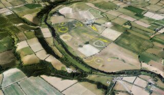
The Great Palisade
The Great Palisade comprises a triple palisade arrangement. The complexity of its design raises questions about its function or functions. Its position relative to the outer enclosure of the Four-Poster mortuary site would suggest that it was constructed later. The section that shows up best is only a small portion of what appears to be a massive construction that might have divided separate ritual zones within the floodplain. Large palisade enclosures are known at other locations but none appear to emulate the complexity and scale of this new example from Newgrange.
It comprises two lines of closely set post-holes, c. 2.5m apart. A band of lighter-coloured crop between them appears to indicate the presence of a bank of earth. This is the innermost of the three palisades.
Outside this and parallel to it is another line of closely set post-holes running continuously without interruption. It appears clearly as a single palisade line, maintaining a consistent distance of c. 30m. Outside this again is evidence for yet another palisade at a further distance of c. 15m. This outer line does not appear to be continuous, as it arcs inwards on encountering the upper edges of the palaeochannel.
The course of the triple palisade can be traced for a distance of c. 900m. It is likely that it may have an irregular curvilinear shape. It is tempting to think that it may enclose the Newgrange Passage Tomb and the entire ridge.
Such palisade enclosures are known from Neolithic complexes in Britain, as at Hindwell, Mount Pleasant and West Kennet, but the triple arrangement at Newgrange appears to be unique. The planning and construction of such a large, complex palisade feature must have required massive resources.
Even with our currently limited knowledge of the northern portion of the triple palisade it is clear that it would have functioned as a significant division of the ritual landscape of the Newgrange floodplain. We can already see that the large, discrete henge monuments lie outside the triple palisade feature, while other monuments would have been contained within it.
Conclusion
The discoveries made by Anthony Murphy and Ken Williams and the aerial surveys conducted by the National Monuments Service have provided dramatic additions to the record of the monuments on the Newgrange floodplain. Work is continuing on the analysis, interpretation and mapping of the aerial photographic record of the floodplain, the World Heritage Site and its environs.
The additional information on known sites and the identification of ‘new’ sites present us with a layout of a ritual landscape that invites further detailed analysis. The henges, for example, occurring in two groups, are ranged along the banks of the River Boyne, but equally they appear to relate closely to the course of a particularly large palaeochannel on the floodplain.
The delineation of the ritual landscape by the Great Palisade is likewise of great significance. Whatever about its precise chronological relationship with the henges, the apparent deliberate segregation of the Newgrange ridge and slopes is of immense interest.
Commenting on the results of the National Monuments Service survey and ongoing works at the Brú na Bóinne Visitor Centre, Minister for Culture, Heritage and the Gaeltacht Josepha Madigan TD said:
‘These remarkable archaeological discoveries are a significant reinforcement of the UNESCO World Heritage inscription and will transform our understanding of Brú na Bóinne. It is wonderful new knowledge for the OPW’s Brú na Bóinne Visitor Centre, which is being redeveloped with the support of my Department and Fáilte Ireland, which will let us tell the ancient story of this wonderful landscape to an international audience and help attract an increased number of tourists to the area, contributing to the local economy.
These discoveries will inspire much interest and will attract further research and interpretation. My Department looks forward to working with the landowners and academic institutes and researchers in the years ahead on ensuring the secrets these sites still hold are revealed.’
Further details of the sites described above can be found on the Department of Culture, Heritage and the Gaeltacht website: https://www.archaeology.ie/sites/default/files/files/bru-na-boinne-interim-report.pdf.