Buildings
New Findings on the Buildings in the Middle/Lower Yard at Ormond Castle

By Emma Collins
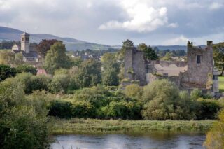
Ormond Castle is located on the banks of the River Suir in Tipperary. The earliest reference to a castle at Carrick is in 1315, when Edmund Butler (d.1321) was granted the castle and manor of Carrickmagriffin by King Edward II. After Edmund came to Carrick he had a castle built on the south side of river in Carrick-Beg. In 1336 James Butler, 1st Earl of Ormond, granted this castle to the Franciscans. Part of this friary church still stands and is used today as St Molleran’s parish church. A new castle was built on the north side of the river in the south east corner of the medieval walled town. This consisted of a D-shaped enclosure with a watergate that fronted directly onto the river. The dilapidation of the castle started in the 17th century when it was attacked by Oliver Cromwell. How seriously the castle was damaged it is not known but in 1661 Elizabeth Butler, then Duchess of Ormonde, wrote to her agent that ‘the house at Carrick is in a ruinous condition’. By 1743 Ormond Castle is described in the following terms ‘Here are the ruins of a fine old house that did belong to the late Duke of Ormond’. The Butler family abandoned Ormond Castle in the 18th century and it was let to various tenants. Unfortunately, at some point probably around 1816 Mr Wogan, a solicitor, stripped out most of the core buildings in the middle/lower yard.
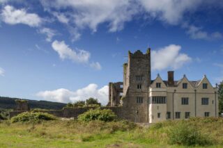
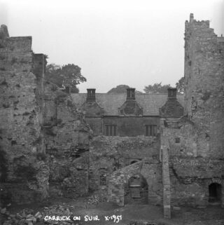
The castle was placed in state guardianship in 1947. Conservation works started in the courtyard in 1951 prevented any further deterioration. The surviving elements of the castle include two 15th century towers and the 16th century north range. Following archaeological investigations carried out during the recent restoration works remarkable details of previously unknown buildings in the middle and lower yards have been uncovered. This information provides a unique insight into the development of the site from the 14th century onwards.
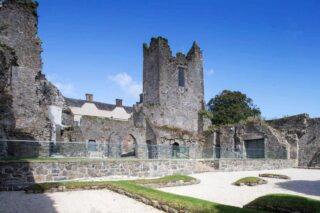
The west side of the middle/lower yard at Ormond Castle is better understood than the east side. Here, the shells of three medieval buildings can be seen. The middle and southern bays had a vaulted ground floor and chamber above. The vaults were aligned east/west but one of these was switched 90 degrees to accommodate an oriel window at first floor level. This would have lit the dais end of the great hall. Historically, the dais was a part of the floor at the end of a medieval hall, raised a step above the rest of the room and was where the top table was located. This block was linked to a watergate with a curved curtain wall which would have allowed access for goods etc. from the River Suir. The ruin of the watergate still stands today over an arched entry. From the height of the arch we can be confident that the entry was for boats. A sudden drop near the watergate suggests the building probably had a central dock and a quay on one or both sides. There is no slot for a portcullis but hanging eyes for a pair of doors or gates can be seen on the inside. The east side of the middle/lower yard has the preserved limb of an unusual early building. It is likely that this block was also linked to the watergate with a curved curtain wall. This symmetry was later abandoned with the addition of an L-shaped, two storey block in the southwest corner of the castle. This block, with an elegant ogee window likely predates the 15th century west tower.
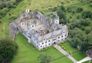
It is unclear how the north side of the early castle was enclosed. No wall of sufficient thickness has been found. The 14th century castle yard may have continued north. The outside wall on the east side was originally town wall or a castle enclosure wall which met the town wall further north. Carrick’s town walls were mentioned in the Ormond Deeds in 1324 and it appears that by 1344 at least half the town was enclosed. Following two attacks on the town in the early 1400’s a murage grant by Parliament in 1450 paid for the town to be fully walled on the northern side of the river Suir. Approximately 150 meters of the town wall remains upstanding in the north-western corner of the castle park.
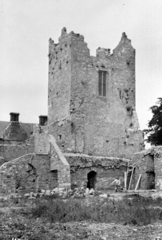
The smaller tower (c.1450) on the eastern side is five stories high. Built in two stages, it was added to an L-shaped building already standing two storeys high. The vault at the bottom of the tower is intact. An ogee window on its west face suggests it is contemporary with the L-shaped block in the southwest corner. It is likely that the second tower with a turret on its southwest corner was added on the west side towards the end of the 15th century. Now a shell it is also five storeys high. Several stages of building can be seen. In contrast to the east tower there is no vault over the ground floor. Both towers have been altered extensively over the centuries. The north range was too small to have functioned as a self-contained building and great care was taken to integrate the two towers into the north range in the 16th century. This process involved inserting fashionable fireplaces and large windows and doors were broken through.
These discoveries in the middle/lower yard immediately challenged the current understanding of Ormond Castle. As part of a wonderful new interpretative exhibition commissioned by OPW Heritage Services with the support of Fáilte Ireland visitors can now view for the first time a detailed 1:90 scale model of the castle at its height. These findings have prompted many questions and will hopefully provide the basis for continued research in the future.
About the author
Emma Collins is Head Guide at Ormond Castle. She holds a BA in Economics and Politics and an MA in Politics from UCC. With the OPW since 2008 she has also worked in Cahir Castle and Kilkenny Castle. She has particular interest in women’s history.