Restrictions
- No climbing
Cahergall Cashel is a state-owned National Monument in the care of the Office of Public Works
WARNING: It should be noted that these sites are unguided and a level of care and caution should be maintained during all stages of your visit. The Office Of Public Works (OPW) will not be held responsible for any damages, injuries, or losses that occur
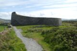
Cahergall Cashel, known locally in English as Cahergal and in Irish as An Chathair Gheal (The Bright Stone Fort), is the most impressive cashel or stone built ringfort amongst a group of three cashels located along the northern bank of the Valencia River Estuary near Cahersiveen. Cahergall Cashel was built on the crest of a slight ridge, and to its north the fort is skirted by a low rock-face. The site is one of 60,000 ringforts built across Ireland between 550 – 900AD as defensive homesteads for wealthy farmers. The construction, size, and scale of this fort, and its location so close to the estuary, may indicate that it was intended to have a more military or defensive role than most other monuments of its type.
The site consists of a massive circular rampart, which features terraces and interconnecting steps on its inner face, and encloses a large central hut. The hut was recently excavated in the 1990s by the National Monument’s Service as part of the extensive programme by the OPW to repair and conserve the monument. The walls of the fort are up to 4 metres high in places with a width at the base of 5.5 metres. The interior wall has two terraced walkways set at an average of 1.15 metres and 2.7 metres high above ground level, which are each divided into nine sections by inset arrangements of opposing steps. These terraces would probably have been used by lookouts, sentries and guards protecting the cashel. These sections average .6m wide and vary in length between 4.5m and 7.5m. The steps to the upper terrace tend to occur midway along the lengths of the individual sections of the lower one. At two points, at NNE and SW, access is gained to the top of the rampart from the upper terrace via sets of opposing steps.
The central hut is of drystone construction and prior to its reconstruction and conservation its interior was filled with rubble and its wall was only preserved above ground level to a height of 1.7 metres. Local tradition held that the hut had originally had a corbelled stone roof which collapsed, and the surviving section of wall had a slope which suggested this had been the case. The hut had an internal diameter of over 6 metres and excavation uncovered a large central hearth-pit which was used for heating and cooking and several hundred stake-holes suggesting internal wooden divisions or structures. There was little evidence for activity on the site prior to the construction of the hut. Artefacts discovered included quern fragments, scraps of sheet bronze and iron slag suggesting metalwork activity on-site. A drystone structure of rectangular plan formerly stood against the northern inner wall of the fort. A pin sharpener and three fragments of a quern stone from Cahergall are on display in Kerry County Museum today.
Visit Historic Environment Viewer for more information on Cahergall Cashel
Protect our Past - Click here to read about the importance of protecting our country’s unique heritage sites
This national monument is protected in accordance with the National Monuments Acts 1930 to 2014
The childhood home of Daniel O’Connell
Approx. 23.2 km from Cahergall Cashel
The story of a remarkable island community
Approx. 24.1 km from Cahergall Cashel
An island monastery towering over the sea
Approx. 27.1 km from Cahergall Cashel

Unlimited access to our heritage


