Notice
Errigal Ringfort is a state-owned National Monument in the care of the Office of Public Works
*Not for Public Access*
WARNING: It should be noted that these sites are unguided and a level of care and caution should be maintained during all stages of your visit. The Office Of Public Works (OPW) will not be held responsible for any damages, injuries, or losses that occur
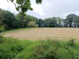
Errigal Ringfort
Errigal Ringfort, situated in the south-west facing slope of a drumlin, overlooks the Annalee River to the south. The ringfort is defined by an inner earthen bank and flat-bottomed fosse and an outer bank, making Errigal a bivallate ringfort.
The entrance, 2m wide, to the ringfort was from the SSE. Errigal Ringfort has a diameter of 34m and slopes towards the south. The inner earthen bank encloses the ringfort is at its highest of 3.3m at the western side. Ringforts are found throughout the country and over 60,000 examples have been identified. They were typically built in the Early Medieval period, and were homesteads for families and animals.
Visit Historic Environment Viewer for more information on Errigal Ringfort
Protect our Past - Click here to read about the importance of protecting our country’s unique heritage sites
This national monument is protected in accordance with the National Monuments Acts 1930 to 2014
Gallery


Nearby sites to visit
Loughcrew Megalithic Cemetery
A high point of Neolithic art and design
Approx. 36.1 km from Errigal Ringfort
Fore Abbey
Discover the mystical legacy of St Feichin
Approx. 43.6 km from Errigal Ringfort
Old Mellifont Cistercian Abbey Monastic Site
Visit Ireland’s very first Cistercian foundation
Approx. 55.0 km from Errigal Ringfort

Battle of the Boyne Visitor Centre – Oldbridge Estate
Where two kings fought for Europe’s future
Approx. 58.7 km from Errigal Ringfort
Carlingford Castle
A Norman citadel in the shadow of a giant
Approx. 59.4 km from Errigal Ringfort
Brú na Bóinne Visitor Centre: Newgrange, Knowth and Dowth
Step into Ireland’s richest archaeological landscape
Approx. 59.5 km from Errigal Ringfort